Tom's Blog

Wednesday, January 25, 2012

Nice restored savanna at UW-Madison Lakeshore Path
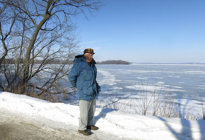

UW-Madison has a spectacular shoreline along Lake Mendota. Including Picnic Point (seen in the background in this photo), there is over 4 miles of lake frontage. Yesterday the weather cooperated and Kathie and I walked from Picnic Point to the Memorial Union. Among other things, we walked past Willow Creek Woods, which has recently been converted into a nice restored oak savanna. Some of the largest bur oaks in the area are present just a stone's throw from the lake. (According to the Lakeshore Preserve web site, there are 23 large oaks in Willow Creek Woods.) For many years, this savanna had been hidden behind a dense undergrowth of invasive shrubs, which blissfully are all gone. Although this is the wrong time of year to see herbaceous plants, we did see some strands of savanna grasses. Also, there were lots of small blue flags scattered around, places where (we assume) plugs had been planted last fall.

This savanna has another feature, a large Native American burial mound. The campus is studded with such mounds, from Eagle Heights to Observatory Hill. These mounds, often in the shape of animals, were built by Middle to Late Woodland peoples, and date from 0 to 1200 A.D. Although these peoples are long-gone, their heritage lives on in these effigy mounds. (Azitlan, near Lake Mills, was built by Late Woodland people as was the great city of Cahokia, in Illinois.) Archeological work has shown that the Willow Creek site was once an ancient workshop or village. There has been quite a bit of research on the mounds of Madison, going back to Charles E. Brown's work in the early 20th century. A nice summary can be found in a publication of the Wisconsin Historical Society, which can be found at this link.

These mounds are topped by a few of the largest oaks.

As Kathie and I neared the Union, we were entertained by someone speeding across the lake with a skate sail. There was too much snow for skates, so he was using skis.

In the Union we enjoyed some hot tea and coffee from Peet's, a long-time Berkeley company that seems to have found its way to Madison.

Finally, we took the campus bus back to where we had started our walk. Since it was class change time, the bus was jammed, so we became strap-hangers. Nice afternoon.

Friday, January 20, 2012

Lake States Fire Webinar 1-19-2012


The Lake States Fire Science Consortium is an entity available to anyone in our area doing prescribed burns. Supported by grants, it is adminstered by Ohio State University but the committee includes people from all the "lake states". Here is their mission statement: "...to accelerate the awareness, understanding, and adoption of wildland fire science information by federal, tribal, state, local, and private stakeholders across the Lake States from Minnesota to New York, and the adjacent Canadian provinces of Ontario and Manitoba." Anyone interested in joining and receiving their monthly newsletter and other announcements should access this link.

One of the activities is a series of "webinars" dealing with various aspects of wildland fire. These are held on the third Thursday of the month at 9:30 AM Central time. All the webinars are archived, so if you miss a "live" presentation you can still "attend" the event. (Check the web site)

The webinar topic yesterday was Use of Prescribed Fire to Regenerate and Restore Red Pine Ecosystems. The presenters were Minnesota folks in the northern part of that state, where red pine is an important ecosystem. Although this is out of our direct interest here in southern Wisconsin, I still found the webinar interesting because of the general principles presented.

A principal goal of prescribed burning in these northern red pine ecosystems was the control of hazel (Corylus americana), a shrub that is a dominant member of the understory there. Hazel can shade out and greatly inhibit red pine reproduction. Since hazel is an important member of the understory in our oak savannas, we often discuss whether we should be controlling it. Although it is not out of hand here, apparently it is a real menace in northern Minnesota.

In the red pine ecosystem, prescribed fire is the best way of controlling hazel. Not with spring (dormant season) burns, however, but with mid-summer burns. In fact, dormant season burns not only do not reduce hazel, but actually increase its density. This is because spring burns only top-kill hazel, followed which it resprouts vigorously. In contrast, mid-summer burns actually kill the shrub, although the best results are obtained by burning annually. Even biennial burns are not as effective, and burns at less frequent intervals are virtually useless.

Since we rarely do summer burns in southern Wisconsin, I was interested to learn how these burns are done. The strip headfire technique is used exclusively. However, since the burns are being carried out in the heat of the summer, there is a great possibility of killing the red pine itself. Because of this, summer burns must be carried out exclusively as backburns. To keep any head fire from developing, the strips are kept very close together, as the photo below shows.
Summer burns are thus quite time consuming. Smoke management is more of an issue than it is in the spring and there is lots more mop-up.

The photo below shows a burn in a similar area carried out in the spring (dormant season). The strips are lots wider, and the whole burn can be carried out lots quicker.
All of our savanna and woodland burns are also carried out as strip headfires.

I found this webinar quite interesting and useful, even though it was in a different type of ecosystem.

The schedule for the next few webinars is shown on the photo at the top of this page.

Monday, January 16, 2012

Variable precipitation data; southern Wisconsin

The lack of snow this winter got me thinking about how variable our precipitation is in southern Wisconsin. I obtained from the State Climatology office data for our area that permitted me to study this variability in some detail.

The data I used came from weather stations nearby. For the years 1995 through 2001 the data were from Blue Mounds, and (after that station was closed) from Mazomanie from 2002 to 2011. These are both close enough to Pleasant Valley Conservancy to be reasonably useful, although some of those heavy summer rains are often spotty. (This year we had one 1.5 inch rain whereas neighbors less than a mile away had less than an inch.)

The data were provided as an Excel file with monthly averages. Note that the snow is converted into liquid water equivalents. Thus, I have a table with data for each month of the year for the years 1995 through 2011. Even this is too much data to present on this blog, so I have reduced it further. (Daily data are also available but these are much too detailed to handle easily.)

I'd be happy to send the big Excel file to anyone who is interested. For this post, I am using the month-by-month annual averages, and the maximums and minimums for each month.

As the graph shows, there is marked year to year variability. The 17-year average of 35 inches rarely happens, and the range is from a low of 24 inches (in 2005) to a high of 44 inches (in 1998). The years 2001 through 2005 constitute a dry period, and the years 2006-2010 a wet period.

However, if you look at the monthly data, you find that some years there may be a single month with a very high or very low total. For instance, even though everyone remembers the huge rainstorms of June of 2008, this was not the extreme high, which was May 2004, even though the rest of 2004 was fairly dry.

The table below gives average data for each month, with both the maximum and minimum for that month, and the year that extreme occurred.

If you look at how the annual precipitation is spread out monthly, Wisconsin can be divided into three separate periods. The period of lowest precipitation is winter, Dec/Jan/Feb/and part of Mar, with about 18% of the total. The months of Apr through Aug constitute the bulk of the precipitation, 61%, and Sep Oct and Nov about 21%. When you consider this breakdown in relation to temperature, it turns out that the months with the highest temperatures are also the months with the most precipitation. This, of course, is our growing season. However, other parts of the United States are quite different. Most of California get almost no rain during the hot summer, but lots during the winter, when temperatures are lowest, which explains why California agriculture is based primarily on irrigation.

Although these monthly figures are useful, it should be remembered that there have been months when the data have been much different. Take a look at the max and min values below.


Month 17-year average Maximum Year Minimum Year
Jan 1.22 inches 2.7 (1996) 0.23 (2004)
Feb 1.483 2.58 (2008) 0.01 (1995)
Mar 2.041 5.54 (1998) 0.34 (2001)
Apr 3.96 7.05 (2006) 1.49 (2003)
May 4.43 11.5 (2004) 1.36 (2007)
Jun 5.26 9.8 (2010) 1 (1995)
Jul 3.79 6.71 (2010) 1.19 (2001)
Aug 4.15 14.9 (2007) 1.36 (2008)
Sep 2.88 6.7 (2001) 0.9 (2004)
Oct 2.55 5.47 (1995) 0.82 (2000)
Nov 2.167 8.1 (2003) 0.22 (2007)
Dec 1.55 3.28 (2007) 0.28 (1998)
Annual 35.483 44.35 (1998) 24.35 (2005)


As the table show, although June of 2010 was very wet, in 1995 June was very dry. In fact, there have been summer periods as long as 4 weeks when it did not rain at all.

In a discussion of Indian grass and little bluestem in an earlier post, I discussed our observations that the former grass is favored by wet summers and the latter by dry summers. During that dry period centered on 2005, the large Indian grass stand in the prairie remnant called Unit 4 was virtually replaced by little bluestem. In the wet period that we have had since 2007 the reverse is the case, and Indian grass is now dominant, as it is on major parts of the south-facing slope.

These precipitation data obviously have phenological implications.

Sunday, January 15, 2012

Little bluestem in Massachusetts coastal areas


On a recent trip to Massachusetts I discovered that little bluestem (Schizachyrium scoparium) is quite common in their coastal areas. This was one of the most frequent roadside plants I saw (and I even saw a piece of roadside where it had been burned).

Coastal Massachusetts is quite sandy. In addition, there are lots of retired cranberry bogs where little bluestem has become well established. The photo above is a typical example.

These retired cranberry bogs are interesting, in that little bluestem seems to become established without any effort on the part of restorationists. Part of the standard agricultural practice here is to put down a layer of sand on top of the cranberries every three or four years. The crop grows up through the sand and sends out upright stems that flower and make fruits. By the time the production bogs are retired, there has been quite a bit of sand buildup. When the retired cranberry production bog is drained, plants are just allowed to recolonize. In the photo above the bog on the left had been retired quite a few years earlier.

In this area little bluestem grows in typical cespitose fashion, as the photo here shows. I knew from the USDA Plant Database that little bluestem could be found in almost all the 48 states, but I was not aware that it did so well on the east coast. In fact, restoration work in areas of coastal Massachusetts, such as Cape Cod, little bluestem is one of the species used in reseeding, then followed by prescribed burns. They don't seem to call these grassy areas "prairies".

The federal publication "Roadside Use of Native Plants" provides a species list for each state, and little bluestem is listed in every state except California, Oregon, Washington, and Nevada. Very few other species have such wide capabilities.

Of course, little bluestem can only compete well in relatively dry areas. In favorable soil with plentiful moisture, it gets out competed by other grasses or forbs.

Thursday, January 12, 2012

Just Posted: 2012 Summer internship opportunities in ecological restoration!

Pleasant Valley Conservancy has just posted job openings for two (2) internships in ecological restoration for the summer of 2012. Excellent opportunity to work with experienced crews doing prairie and oak savanna restoration. Internship also involves some work at Black Earth Rettenmund Prairie.

Both of these sites are State Natural Areas with high species diversity.

Access this link for details

Cleaning out the bird houses


Kathie and I took advantage of yesterday's fantastic weather to finish cleaning out our birdhouses, getting ready for the 2012 crop.

Kathie had cleaned out her bluebird houses on a good-weather day in late December. Yesterday was an even better day, and we cleaned out the two kestrel houses and the wood duck house. Cleaning involves removing all last year's wood chips and bird debris, and putting in some fresh wood chips.

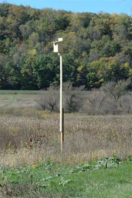
It takes two people to handle the kestrel houses. They are on very tall poles that are articulated so that the houses can be brought down to the ground. The shadows in the photo below show us in action. When Kathie finishes cleaning, I have to reach up to the end of the pole and pull it down, thus raising the house again. (It takes a tall person.)

We have two kestrel houses, but only one is being used. We have had fledglings in the one house every year since we first installed them in 2008. We have seen kestrels around the second house but so far no success with nesting.

The wood duck house is much closer to the ground, but near the boardwalk that permits access to the wetland. This house has been up for two season's now, but instead of a wood duck we have been getting a hooded merganser. Birders tell us that the merganser is a lot rarer than a wood duck, so we should be happy.

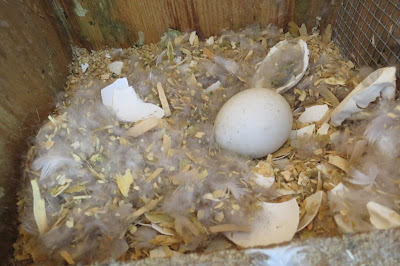
When we opened the wood duck house this year we found one whole unhatched egg, plus the remains of at least one additional egg which may have represented a fledged merganser.

Tuesday, January 3, 2012

Winter grasses in the oak savanna


This snow-free winter has made the grasses on our savannas very attractive. I've been waiting for a nice sunny day so I could take some pix, and today was the day. Cold, but clear and sharp. I fired up my Nikon D70 and wandered the savanna. I needed one ungloved hand to work the camera, so I moved quickly.

The best views at Pleasant Valley Conservancy are of the ridge-top savannas (Units 8, 10, and 11A). The photo here is typical, and this site can certainly be called a tallgrass savanna. The understory is mostly Indian grass (Sorghastrum nutans), with patches here and there of little bluestem (Schizachyrium scoparium).

Those interested in savanna restoration should know that it has taken about 10 years to get to the state you see here. The work has been dominated by tree removal and brush control, especially buckthorn, but these savannas have been burned annually for the past 7 or 8 years, generally in the spring, although we burn in the fall when we intend to plant. And the site you see here (Unit 10, looking east from the west end of the unit), has been planted at least three times. We used a dry-mesic seed mix on the more open (prairie-like) parts and a savanna mix on the areas with less open canopy. Both mixes had Indian grass but only the dry-mesic mix had little bluestem.

Most of the trees visible are bur oaks, although there are occasional white oaks and shagbark hickories. Initially there were quite a few black oaks crowding the open-grown bur oaks, and most of them were removed during the initial restoration (lots of large burn piles in those days!).

Some people don't like to see this much grass, thinking that it crowds out the forbs. However, I think this is misguided. Why?

  • A savanna is not a flower garden.
  • From early May until late August, this savanna is dominated by forbs, and the species diversity is quite high. It is only in early September when the prairie grasses start to take over.
  • Savannas must be burned, preferably annually, and warm-season grasses, such as seen here, make the best fuel. It's a lot easier to burn a grass-dominated savanna than an oak-leaf-dominated one.

Not all savannas have this much grass. It depends mainly on the canopy cover, since these warm-season grasses are only able to compete where sunlight is plentiful. My web site has some details on how we measure canopy cover, which is about 30% for the savanna shown here. Other nearby savannas, with canopy cover around 50%, have lots less warm-season grasses.

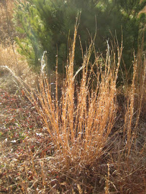
Little bluestem is more of a bunch grass than Indian grass. However, it is a very stable, long-lived grass which does extremely well in dry sites. Once established, it is hard to get rid of (who would want to?). The photo to the left shows a typical clump.

Another consideration is that there is lots of year-to-year variability with these grasses, depending mainly upon rainfall. We have found that in wet years Indian grass tends to dominate whereas in dry years little bluestem takes over. We watched this succession take place in Unit 4, the nearby prairie remnant. When we first restored this prairie in 1998 (mainly by burning) Indian grass flourished. However, during the dry years of the mid 2000s, most of the Indian grass disappeared and the site was dominated by little bluestem. But since 2008 we have been in a wet cycle again and Indian grass is back in force. With global warming in the offing, who knows what changes might occur?


Monday, January 2, 2012

Christmas bird count

Yesterday Kathie, Susan, and I did the annual Audubon Christmas bird count at Pleasant Valley Conservancy. This is the 112th annual Christmas bird count run by the National Audubon Society, which this year ran from December 14, 2011 through January 5, 2012. The count in our area was held on January 1 (New Year's Day).

This is about the 10th year that the count has been held at Pleasant Valley Conservancy. Every year the weather is different. One year the roads were sheets of ice, another year there was a foot of snow. This year there was no snow at all and we could drive up to the top of our service road with no difficulty. However, there was a heavy wind (around 25 mph from WNW), so we did the whole count from our car. It really worked well. I drove and Kathie and Susan counted the birds. We were able to creep along with the windows open, the heater on, and the engine close to idle. After climbing to the top, we started at the East Basin and drove slowly all the way to the west end of the ridge along the service road. Then we took the side road to the Rocky Overlook. Finally, we drove slowly along the whole length of Pleasant Valley Road. We spent about 2 hours counting birds.

Because of the strong wind, most of the birds were hunkered down, so our count was pretty low. However, we did see a bald eagle, a red-headed woodpecker, two hairy woodpeckers, a tufted titmouse, a nuthatch, some chickadees, a large "vee" of Canada geese, and 11 turkeys, plus the usual collection of crows and junkos.

The bird count is organized by "circles", each centered on a city. There are 15 circles in Wisconsin, and anyone can participate. See this link for details.